
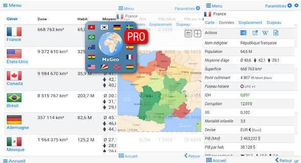
World atlas, world map, and educational geography app. Contains 240 countries and territories worldwide with comprehensive economic and geopolitical data. Includes political maps with regional units (provinces), capitals, and major cities. Designed for smartphones and tablets.
– Maps, flags and complete data for 240 countries and territories worldwide
– Interactive political world, continental maps and countries
– Shaded relief layer for world and continent maps
– Geography quiz challenge for fun learning
– Country comparison and favorites
– Configurable world clock with time zone display
– World-explorer: the smallest, largest, richest and most populated countries in the world
– Selectable color themes for map display
– All data and maps included, no online connection required
– No ads or in-app purchases
No authorization required
Explore the world through offline maps of political continents and countries. Whether in Europe, Africa, Asia, Oceania, South America, or North America, maps of every continent and country are included. Learn where each country is located in the world. See its position highlighted on a digital globe. Create your favorite color theme or choose from various color schemes for the map display.
Do you know the flag of Mauritius? Yes? Perfect. Do you also know which country Mount Everest is located in? The "MxGeoPro World Atlas & Map" quiz helps you acquire geographical knowledge in a fun way.
Choose from six geography guessing games:
– Test your knowledge of the world's capital cities
– Recognize the appropriate country's flag based on the outline map
– Are you familiar with the top-level domains of countries around the world?
– Guess the country highlighted on the virtual globe
– Do you know the ISO codes for countries around the world?
– Do you know the mountains of the world?
Each quiz offers seven regional variations: World, Europe, Africa, Asia, Oceania, South or North America.
A Geo learning app and educational game that's fun for everyone—children, adults, seniors, and teachers alike. Prepare for your next trip abroad while enjoying this comprehensive world almanac, complete with time zones and statistical data such as population growth, unemployment rate, average age, gross domestic product (GDP) by sector, and other key figures. Or, get ready for your next geography lesson with this awesome digital world map. If you're not traveling, our world atlas lets you explore the world virtually. Enjoy the complete world atlas, including Europe, Asia, North America, Africa, Oceania, and South America, with all countries and regional units, capitals, and flags.
What's new:
– Bug fix: favorites, world clock, and country comparison
– New: historical maps of the political world and the continent from 1900 to 1960
– New: Maps of historical countries from 1900 and 1960
– Country data update
– Added the Åland Islands and the Canary Islands
– Maps: improved zoom, bug fixes and performance improvements
Version : Pro v5.0.4
Compatibility Android 4.1 or higher
Size : 51.8 MB
This article was updated on December 23, 2017